
POCKETS FULL OF SAND AND EYES FULL OF FLIES
This has been a dream of mine for many years, and I feel us Aussies often forget what beauty we have at our back doorstep. With covid preventing external travel, it seemed the perfect opportunity to explore Australia’s natural beauty and ever changing landscapes. We do really have it all here in Australia. From snowy mountains, lush tropical rainforests, to deserts and empty mile long beaches full of amazing marine life. A perfect haven for nature lovers such as us. So we packed up our Pajero Ruby, Fitted the rooftop tent, awning and filled her up with our belongings and off we went! The aim was to reach Exmouth in Western Australia and see as much as we could in between.
A special note: I want to acknowledge the aboriginal people and the traditional owners of this land and thank them. We live, we explore and we soak up the beauty of this land, their culture and country. I pay my respects to the Elders past and present.
QUEENSLAND
STARTING OUT
Our trip to Western Australia began on the back of cyclone Kimi. As we departed Port Douglas to head south and hopefully out run the cyclone that was set to cause destruction right in our path of travel to Townsville. Due to travelling in the height of wet season there were many things to keep in consideration as we were at the mercy of Mother Nature. Having originally wanted to take our journey to WA via the Savannah Way (across the top of Australia). Flooding had caused us to change our plans as those roads were impassable. So we took the Mt Isa route aka the Overlanders Way healing west from Townsville.


MISSION BEACH
The first stop after leaving Port Douglas was mission beach, and our mission was ‘Cassowary’. Turns out the cyclone decided to follow us all the way there and hit the camp site that night as a tropical low. So we had very little sleep, feeling as if were were about to be swept off the roof of our car Ruby. I imagined being blown into the wind like the house in The Wizard of Oz. By morning all was well and we commented the mission. Driving around mission beach all morning looking for cassowary birds on the road. We were successful and actually spotted two (one had babies with it!). The best time to see them is early morning and they do tend to be easy to find road side as you drive around. There are some really beautiful rain forest walks along little babbling streams here too. But, the mozzies. Ollie said it was like being in the Amazon. You could not go on a leisurely first walk, it was more of a mozzie run. Quickly walk take some photos and take in the scenery but you’re walking in lava because if you walk too slow you have your own mozzie swarm. Again, wet seasons magic has struck us a again!

WALLAMAN FALLS
Before we heading into the deep outback where we knew water would be something we won’t see for a while we made a detour to visit Wallaman Falls which is Australia’s tallest single drop waterfall. It’s about 1.5 hours west from Townsville. If you’re going to do any of the waterfalls, do this one! It really was something special, the size its truely impressive and its worth the detour. On the road to the falls we stopped several times as wildlife on the road there was very abundant. We found trees full of large bats, wild dingos, wallaby’s as well as various birds of prey. There is a lot to see on this route.

MACROSSAN
So we officially now started to head into the ‘outback’ and away, far away from our beloved big moist, the ocean. Leaving that far behind was definitely tough and we would have to wait until we reached the croctastic waters of Broome to see it again. The camp site for the night was a free camp site just before Charters Towers called Macrossan Camp off the Flinders Hwy. It sits right on the Burdken River in a beautiful spot. I’ve said it many times this trip, but the best camping sites are definitely the free ones. And they are hard to find and not openly advertised online, I found we tended to stumble across them by accident mostly.

MOUNT ISA
We quickly did some food shopping and grabbed some essentials in Charters Towers and then continues onwards to the heart of mining - Mt Isa. . Between Mt Isa and Charters Towers there were a few small little towns, the kind where you see the sign for it and drive through and almost don’t even register there was even a town. These places are also almost like ghost towns, its quite strange to stop there especially during covid so the lack of tourists everywhere makes things feel eerily quiet. The drive onwards into Mt Isa becomes more and more red as you go and hotter and hotter. The road before you reach Isa is actually a nice drive as you wind through some pretty nice rock formations and hills. The landscapes out here really do change fast from big rocky hills to flat flat flat fieldss of grass and the occasional dead cow. Camping at Mt Isa was our first proper introduction to the plague of insects that love human sweat in the outback. The flies, the ants and again the mozzies. As much as I tried to mentally prepare myself for the flies before the trip. They really do drive you insane within a few minutes. Fly head nets will become you’re new favourite fashion accessory. When we were in Anaconda I was saying to Ollie we should buy them he was very much like “oh nah we don’t need that do we?”…. guess who was the first one of us to bang that on our heads!?


NORTHERN TERRITORY
MIDDLE EARTH INTO THE NT
We crossed the border into the Northern Territory at the covid check point, hoping they would let us in. With our border declarations filled and luckily we had been in only covid free areas of Norther Queensland we were allowed in. As soon as you cross into the NT the fly level goes up. Now that we were fully aquatinted with the flies, it just became the new norm. But sometimes, you’d get out of the car and it would take a few minutes for your swarm to arrive and you’d be thinking “oh nice there’s no flies here”. Just no, you’re wrong every time. There is always flies. Now enough about flies. I hope I’m not putting you off visiting, this part of Australia really is worth the journey and I’m so glad we did it. Driving out here on the Barkley Hwy its one of the flattest areas and you really do start to think the flat earth’s had it right all along.


BARKLY HOMESTEAD
I really liked Barkley homestead, it had a very nice country vibe to it. The bar was very charming in a rustic kind of way and the staff were friendly. All the local alcoholics were hanging out having a bit of a banter about politics and the such. I love the fact that when you’re in a country outback place that the fashion is on point. The Acubra hats, the plaid shirts, the swagger. Again covid effect was evident so the camping ground was very empty and we had a pretty nice spot just for ourselves. We enjoyed a pub feed and some cold beers at the homestead under the cold AC which was nice for a change. Next morning we were headed south bound to the Red Centre, final destination Alice Springs.


ALICE SPRINGS
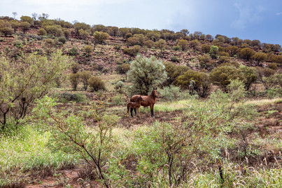
When you look on a map of Australia Alice really is smack bang right in the middle. And the closer you get to it the redder and dryer everything gets. The hills start so have a definitely red glow about then as the rocks seem to emit their own kind of red light. We camped one night in Alice Springs and then bombed it down to the big rock via a rather adventurous rout called The Mereenie Loop. This is a 4x4 track that takes you out the back way to Kings Canyon. You need to pick up a permit for this road for $5 from the info centre in town before departing. We chose to drive along Namatjira Drive which takes you along the MacDonnell National Park and then connects with the Mereenie Loop. This route is beautiful with many points of interest along the way such as Simpson Gap and other nice gorges. The mountain range itself was stunning with swirling lines of rock in different colours along its top. Due to the rain we did have to drive through several rivers and floodways so don’t take this road without a 4x4.


THE MEREENIE LOOP
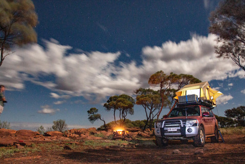
So originally this road looks like some kind of short cut to Kings Canyon. But it’s more of a long cut as the road was pretty bad and it seemed never ending. BUT… we didn’t regret taking it as it was so interesting with lots of nice views, wild brumbies and other animals. The road was very corrugated, muddy and flooded in some sections. Still very doable but it just took ages. When we were nearing the end of it we passed another 4x4 (only 1 in 4 hrs). They were asking how much further does the road go as they weren’t enjoying it very much. I almost laughed as we had been on it almost all day! Anyway they didn’t turn around and they kept going so I hope they made it ok. We stumbled across a pretty epic free 24hr camp spot at the end of it called Ginty’s Lookout. You could park and camp right up on the edge of a rocky ridge that over looked onto kings canyon in the distance. The sunset was postcard quality and later the stars and full moon really put on a show. It was easy to believe you were the only humans on the planet at this point. So much space, fresh air and beauty all around. We slept so well that night as it was surprisingly cool after the oven that was Alice Springs.


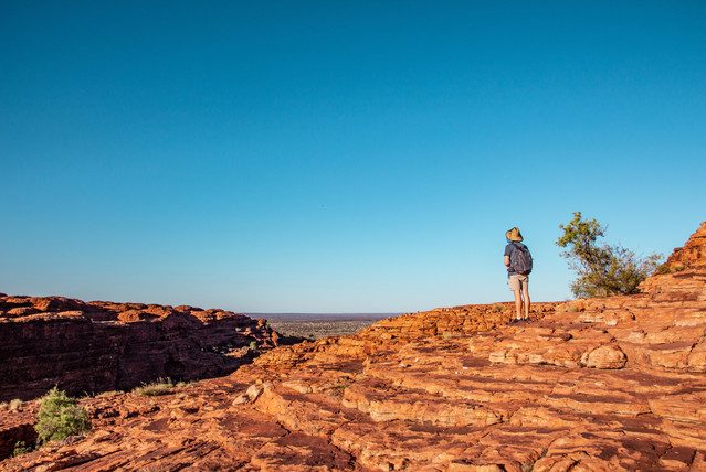
KINGS CANYON
In order to beat the heat so we could make the Kings Canyon Rim walk we got up at 5am and drove the final 20mins to the canyon. The rim walk is about 6-7km long depending on what detours you take. And it’s pretty easy apart from dealing with the heat and the steep steps at the beginning. These rock formations are seriously impressive and are apparently formed from ancient sand dunes. The canyon its self was made by a big crack in the rock that collapsed inwards on its self and corroded over time. There is a waterfall, lush forest and river running through it which just adds to the beauty. Reaching the end of the track was the hardest part as that was when you’re in full sun and even by 9am it’s stinking hot. But if you’re here in winter you will have a better time. We were crazy enough to embrace the elements of peak summer and wet season just for the added adventure!? :I


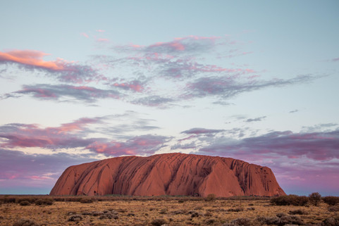
THE BIG ROCK - ULURU
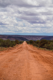
Ok so we couldn’t go all this way without seeing the beating red heart of Australia. That rock being named Uluru or by some Ayers Rock. Leaving Kings Canyon to make our way to Uluru it was a hot 4hrs drive through the desert. And its at this point you’re in proper desert with like dunes, dead animals and dead trees. Everything is RED. Like really red. It’s so red that the clouds themselves have red undersides from the light bouncing off the earth. It’s pretty insane and something you have to experience for yourself. Its such harsh and alien landscape but it is so so beautiful. And it amazed me how much it changed with each hour of driving. Once you’re about 40km from Uluru you will get your first glimpse of the big rock. And woah it is so big!!! Having seen pictures so many times you think you know what you’re in for. But it is very impressive and it protrudes from the flat and red landscape like nothing I have seen before. It boggles the mind how it even got there amongst so much flat nothingness. It’s at this point too that you realise the heat has levelled up again and the air outside of the sweet sweet AC of the car is an actual oven. You look around wondering how does anything survive out here? The trees that are spotted around seem to be curling as if cringing from the heat and the birds are sat around wide mouthed as if holding a silent scream (I think they do this to cope with the heat?). Pulling into Yulara camping ground we found some shade and waited until sunset to get a closer view of Uluru. To get access to the Uluru - Kata Tjuta National Park there is a $38 fee per person for a 3 day pass. We drove in and parked up at the sunset point to watch the show. Sunset and sunrise is the best time to view the rock. With the descending go the sun, the rock face changes colour and it truely is a spectacle of nature. Doing this trip in the heat of summer meant the day was for relaxing or driving from A to B (AC full blast) and the mornings/afternoon were for adventure. As late or as early as possible so to avoid heat exhaustion. Heat exhaustion did strike us a couple of times so really be ready for it as it doesn’t take much for it to happen. Throbbing headaches and just overall sweats leave you feeling pretty awful. So be prepared and drink water with added electrolytes, this helps a lot. The temp was pushing 45C plus each day and to put that in perspective - squatting for a pee in the desert, you can literally feel the heat from the earth burning your butt. You could fry and egg out here or perhaps slow roast some lamb. Aside from all this, the heat and everything else it’s all part of the adventure and the experience. It wouldn’t be the beautiful place it is without it.


DEVILS MARBLES
These are some incredible rocks. And as I may have mentioned the NT has no shortage of nice rocks. The Devils Marbles also known as Karlu Karlu is an ancient meeting place for aboriginal people and holds great cultural and spiritual significance. At The Devils Marbles as there is a camp ground which was cheap ($12 per night). The location for the camp is stunning as you’re surrounded by all those massive round boulders and wilderness. We had pretty heavy rain and storms that night and possibly the most insane lightening I’ve ever seen. I for sure felt like something was about to be set on fire near by, pretty spectacular to watch. Next plan was to head back the way we came up towards Kakadu National Park.


DALY WATERS
A good pit stop, in fact a pretty iconic one and my favourite outback pub is Daly Waters. Full of character and classic Aussie stuff (the place is full of random memorabilia) this is not to be missed.


MATARANKA THERMAL SPRINGS
Before we delved into the depths of Kakadu we made an overnight stop in Mataranka where there are some thermal pools. Don’t bypass this place it is really worth a stop. The camp ground is close to the pools and they are perfect temp for a leisurely swim. The colour of the water is pretty amazing and it’s hard to do it justice with photos!


KAKADU NATIONAL PARK
So finally we drove into Kakadu National Park, made a quick internet stop to buy our entry passes ($25 per person for 3 days). There is an instant change is landscape once you get close to the park from dry and red to lush, green and tropical with waist high grass. It is SO beautiful and a real change of scenery for the eyes after so much red dryness. One challenge we did face in the NT at about this point was that ants had decided to make our car their new house on wheels. Arriving in Kakadu and I had this feeling like something tickling my toes. Pulling over pretty quickly I found that a whole nest of ants had erupted from under the car pedals and were speedily making their way up my legs! Yuck… the creatures really give you no peace out here. We made our way through Kakdu stopping off at various sites such as rock art, view points and we did do a yellow river cruise to see some crocs. From this cruise you really do get a proper sight into just how massive the wet season floods are here. Sadly many of the waterfalls and popular camp spots were closed due to flooding which was quite disappointing but the trip was still amazing. We will just have to go back another time. When visiting Kakadu - prepare yourself for the mozzies and March flies. They are next level here. One pretty nice thing to note here was that there are so many animals around. We saw so many wallabies. Infact we had a bit of a BBC moment as we were having breakfast we saw 2 dingos hunting a wallaby right through our camp.


LITCHFIELD NATIONAL PARK
Ok finally… waterfalls we could access! Wangi Falls is where we headed that has a HUGE double waterfall which was pumping with all the recent rain. I think one of my favourites from the trip and you can camp a few minutes walk away from it. Again, no swimming because of crocs. We did find one that you can swim in that was the next stop, Edith falls which isn’t so far away (couple of hours) and that one you can swim in (involves a 20mins hike up to access). Hiking up to Edith falls was HOT and sweaty and we did encounter the biggest huntsman spider in our path. Eew. Oh and then I brush up against a tree and was stung by a massive bush wasp. Felt like a hot poker being jabbed into my back. Oh the joys of the bush and all its creatures. The swim to cool off was much much needed by that time!


WESTERN AUSTRALIA
TO THE WEST!
At this point we were really itching for the ocean so it was time to make a move on and start the loooonnngggg journey towards the West Coast of WA. Having already driven about 7,000km since leaving it really goes to show just how much distance we had covered so by this time!
We applied for our border passes and headed off. Crossing the border during covid was an interesting experience and felt like crossing into another country. After a brief interview with the police while they assessed whether or not our blundering through the outback would leave us Covid free. They let us in but sadly we had to sacrifice our Capsicum as he wasn’t allowed across borders. Worth noting: you can’t bring any fresh fruit, vegetables, honey or nuts/seeds into WA.

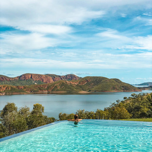
LAKE ARGYLE
This place was mint! Some backpackers we met earlier tipped us off about this place and so glad they did. The camping site has an infinity pool overlooking the massive man made lake. The view is pretty spectacular and perfect for those influencer in the wild shots. We decided to spend 2 nights here to cool off and recharge after so much driving. Driving in the NT means you travel such vast distances each day and it’s pretty exhausting. Each place of interest is often far from the next with not much in-between. It was a relief to slow it down for a bit and catch our breath while feasting our eyes on the expanse of the lake. Apparently there is a bout 10,000 freshwater crocodiles in there - we didn’t swim to find out if that’s true or not. The pool was sufficient enough!


LONGEST DRIVE YET
The next leg of our journey would take us into some of the most remote regions of WA along the Great Northern Hwy. Which until you reach Broome there is little and nothing in-between. We were in fact rightly advised not to make many stops along this rout if possible as many of the towns can be unsafe at night. An issue I’ll not delve into as I would need many more words to give this topic proper justice. White people’s treatment of Aboriginal people is something that is right up in your face out here and in the NT and the deep deep issues that encompasses these beautiful people is hard to face.
Another option for this journey would have been to take the epic and infamous 4x4 track ‘The Gibb River Road’. Which as many people said would either make or break you (and you car). Again wet season so not really a good idea and it was the next day that actually it flooded and was closed anyway so definitely wasn’t an option. We began to plan how to get to Broome and the only option was to take the Great Northern Hwy. Along this journey there is very few places to see along the way so we almost made it to Broome in one go. We had been advised to not stop anywhere along this rout as it can be a pretty rough area. If you ever pass through Halls Creek you will understand why this advice is given. It’s not a very traveller friendly area. So we just kept driving onwards to Broome. It was getting dark and stormy and we were still about 2.5hrs from Broome and then we were hit by all sorts of natural road foes - wild horses, locust plagues and flooding. Plus we were hit by some pretty crazy rain and lightning so we called it a night and camped at a 24hr rest stop east of Broome.


BROOME
Next morning we finally finished the last leg to Broome, we had driven almost 1,100km the day before and were officially pooped. On arrival in Broome we headed directly to the beach. Cable beach is the main beach in town and you can park your car directly on it. It was such a tremendous relief to see them ocean again and feel the cool sea breeze. In that moment I realised how the outback and desert makes you feel kind of claustrophobic in a sense of constant heat and no air movement. The ocean gives such a sense of freedom and escape I can’t even explain how nice it was to see it again. As much as the outback and desert landscapes were beautiful, my place is always ocean bound. So we recouped a couple of nights in Broome and enjoyed the luxuries of being back in a “big” town. Aka there was a Coles and we even paid for a powered camp site so this felt like a 5 star hotel. North of Broome there is some pretty epic 4x4 routs you can take which is worth some exploring. We stupidly washed the car and then went. Red mud that’s all I can say. We took a short beach side detour to get some drone shots over the sea. The colour of the water here is just gobsmacking. It even looks fake when you take photos of it especially next to the red sand.


80 MILE BEACH
I thought we would take our time to reach Exmouth and slowly explore on the way down. Turns out there is not that much exciting stuff to see along the way. Even google couldn’t help with that. But 80 Mile Beach was one of the places worth stopping for so we headed there. The beach is enormous not only in length but also in width. We camped one night and did some beach driving, Ruby’s first time in soft sand. This is a pretty popular place to view turtle hatchings so that night we looked for baby turtle hatchlings but with no luck. We tried again at sunrise and finally saw a few. Due to the width of the beach there it really is a perilous journey for them and we guarded a few to the water… only to see some reef sharks literally waiting for them. This world is so cruel!


CLEAVERVILLE
Before heading to Exmouth our last stop was Cleaverville Campsite which is another free camp. Pretty sweet spot actually minus the swarm of sand flies. Like super tiny sand flies that could even get into the tent through the fly screen. You’re not safe anywhere in this country! Both Ollie and I were covered in red spots on departure. A pretty speedy departure it was too. The stars were pretty amazing though that night and Ollie got a pretty nice pic that night. Driving the West coast mostly all you see is mining, mining, dust and more mining and dust. Its not the most beautiful leg of the journey but you have to pass through anyway. We aimed to head directly to Coral Bay just south of Exmouth before heading into town so officially end the journey.


CORAL BAY
Pulling into Coral Bay felt like we had finally arrived in paradise, the picture I had in my mind for years since finally became a reality. Turquoise water, white white sand and clear skies. This place is just wow. The bay is full of healthy coral and marine life. We stayed at a beach side camp ground and enjoyed the views and explored the water. On the north and of the bay is a Shark nursery where if you’re lucky you can find some baby sharks, rays and other creatures resting in the shallows. The fact you can snorkel right off the beach and find so much beautiful marine life which isn’t trying to kill you. It’s a ground breaking experience after living in Queensland. One thing that made it such a nice stop was that the temp change was so big. The wind was so cold it was the first time I actually dug out my sweater since leaving Victoria in October.


EXMOUTH
Of all the things I expected could or would go wrong on our trip none of them did. We were so lucky with almost everything. The main thing we were concerned about was having an expensive car break down somewhere in the whoop whoops. Pulling into Exmouth was a huge relief know we had officially finally made it. 9,500km we did in Ruby which was quite a bit further than we had thought. But each part of the trip was so worth it even in sometimes the heat and flies made it a challenge, I would do it again for sure.

Our new home, Exmouth for the next little while (or long while we still don't know). This place is full of adventure and has so much more that i thought in terms of nature and stuff to do. From awesome surf beaches, canyons, beautiful reefs right off the beach. You honestly cannot get bored here. Not to mention the humpbacks, whale sharks and other amazing marine animals just off the back door step. So if you're in the area do come and say hello!


FINAL POINTERS
I don’t think you can ever fully grasp the size of Australia until you do a trip like this. When you see how much the landscape and environment changes even from state to state. It really is like travelling from a lush rainforest in the amazon and then suddenly arriving a few days later in the Sahara. And it’s even more crazy to think back to winter in Victoria where we were surrounded by snowy mountains and -8C temps. There is so much diverse natural beauty our here in Australia, the only way to really appreciate it and find all those special places is by driving. All the best spots were hidden and found by accident far from the main towns or cities. If you’re going to do it, do it right and go with a 4x4 so you have the freedom to explore off road. Be prepared for the heat, potential break downs and the flies. But once you learn to deal with that it can make for the trip of a life time. Don’t plan each stop, as you will find so many hidden gems along the way. Also don’t bring any white clothes, or be prepared to dye them red at the end of your trip!
Essentials that helped: Apart from the obvious survival stuff like water and fuel jerries, tools, first aid kit etc. Some useful things we found pretty essential: Petrol Spy App (good for finding where is the next cheap fuel up), biodegradable wet wipes, fly nets, wide brim hat, paper maps (for non reception area), cooling towel, battery powered fan for the tent, Telstra sim (if you want any signal you need this!) and scrabble. Also recommend to get some decent audiobooks. We made it through 3 of the Eragon books during our trip and it kept us going on those long drives.
It was a long read so congrats if you made it to the end! Thanks for reading.
Officially signing out of the red sand and diving on in to Ningaloo.
B xx
Comments